Byzantine Streets in Thessaloniki: Five Roads That Still Follow the Medieval City’s Logic
Table of Contents
Introduction
The Great Fire of August 1917 destroyed approximately 9,500 buildings across central Thessaloniki and displaced 70,000 residents, erasing most of the city’s Ottoman-era street grid below the old Byzantine walls. Ano Poli — the upper town — was largely spared.
The result is a legible split: below the walls, a French-designed grid of wide avenues laid out from 1918 onward; above them, the Byzantine street network still visible in the curves, gradients and irregular plot boundaries that no 20th-century planner imposed.
Five streets in and around Ano Poli preserve enough of their Byzantine character — in alignment, in the buildings that flank them, or in the monuments they connect — to repay close attention on foot. None of them is a tourist spectacle; all of them are working streets with residents, traffic and the usual friction of a living city.
That is precisely what makes the Byzantine streets in Thessaloniki worth walking: the history is not fenced off or reconstructed. It is simply there, mixed into the ordinary fabric of the place.
Why the Byzantine street network survived above the walls

Thessaloniki was founded by King Cassander of Macedon in 315 BCE and grew into the Roman Empire’s second city in the eastern Mediterranean — a status it retained through the Byzantine period, when it was administratively and militarily second only to Constantinople.
The city’s street pattern evolved continuously from Roman foundations, with the Byzantine grid absorbing and modifying the earlier Roman insulae. The defensive walls built and rebuilt between the 4th and 15th centuries enclosed a circuit of approximately eight kilometres, with Ano Poli occupying the higher northern sector.
Post-1917 reconstruction, supervised by the French architect Ernest Hébrard, applied a regularised grid to the lower city but left Ano Poli largely untouched, partly because the fire had caused less damage there and partly because the slope made large-scale rebuilding impractical.
The result is that the Ano Poli walking guide still traces streets whose alignments correspond to Byzantine-era property boundaries documented in 14th and 15th-century Ottoman tahrir registers — cadastral surveys that recorded the existing urban fabric rather than redesigning it.
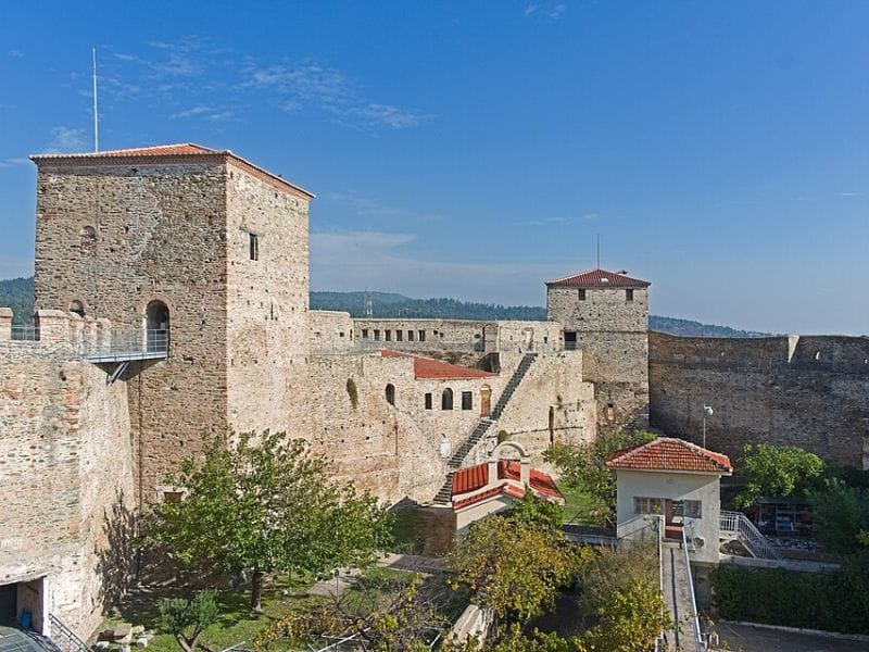
1. Eptapyrgiou Street: the fortress road
Eptapyrgiou Street runs along the inner face of the northern Byzantine defensive wall from the Trigonion Tower westward to the Heptapyrgion fortress — the seven-towered citadel whose name gives the street its own.
The Heptapyrgion dates in its current form primarily to the 15th-century Ottoman consolidation of earlier Byzantine construction, but its foundations and lower courses incorporate Byzantine masonry from the 4th century onward.
The fortress operated as a prison from the Ottoman period until 1989; it was converted to an archaeological site and is now open to visitors from Tuesday to Sunday, 08:00 to 15:00, admission free.
The street itself follows what was almost certainly a Byzantine patrol and access road running inside the wall circuit. The gradient is moderate — approximately 6% for most of its length — and the views south across the city and toward the Thermaic Gulf open consistently as you move westward.
The Monastery of Vlatadon, founded in the mid-14th century by the monks Dorotheos and Markos Vlattis with the patronage of Emperor John V Palaiologos, is accessible from Eptapyrgiou Street via a signed path; the monastery courtyard is open to visitors and the church interior during designated hours.
2. Agiou Nikolaou Orfanou Street: the pilgrim lane
The narrow lane leading to the Church of Saint Nikolaos Orphanos follows an alignment consistent with a Byzantine-era access path to what was, in the 14th century, a dependency of the Vatopedi Monastery on Mount Athos.
The church itself was built in the early 14th century — most scholars date it to between 1310 and 1340 — and contains the best-preserved cycle of Byzantine frescoes in Thessaloniki.
The paintings cover the entire interior across two layers, the earlier dating to the original construction period, and include scenes from the life of Christ, the Passion cycle, and a rare Akathistos Hymn cycle in the narthex.
The church is managed by the Greek Ministry of Culture and is open Tuesday to Sunday from 08:00 to 15:00; entry is free. The street approaches it from the south along a slight incline of approximately 3%, flanked by low walls and residential buildings that sit on Byzantine-era plot boundaries.
The “Orphanos” epithet — meaning “orphan” in Greek — reflects either a tradition of charitable provision connected to the church or a specific historical association with the Orphanotropheion, the Byzantine welfare institution for orphaned children, though the documentary evidence for the connection is not conclusive.
3. Thelanon Street: the weavers’ district
The toponym Thelanon — derived from the Greek for weaving or weavers — identifies a street in the university district that preserves the name of a Byzantine craft quarter.
Silk production and textile dyeing were significant industries in Byzantine Thessaloniki: the city hosted an annual October fair, the Demetria, which was one of the most important commercial events in the eastern Mediterranean from the 10th century onward, and silk goods were among its primary trade goods.
The 12th-century historian Ioannis Kinnamos describes the fair as attracting merchants from across the empire and from Italy, the Levant and the Black Sea coast. The street itself now passes through a district of university buildings, student cafes and low-rise residential blocks.
Its Byzantine character is not visible in standing buildings but in the irregular plot lines and the compressed scale of the street frontages, which reflect medieval workshop-and-residence typology rather than later development patterns.
Archaeologists excavating construction sites in the area between 1990 and 2015 documented Roman foundations beneath Byzantine floor levels, confirming continuous occupation and industrial use from the 2nd century AD onward.
4. Isavron Street: ceremonial route and dynastic name
Isavron Street takes its name from the Isaurian dynasty, which ruled Byzantium from 717 to 802 AD and is most associated with the iconoclast emperors Leo III and Constantine V.
The street’s alignment suggests it formed part of a processional corridor connecting the administrative core of Byzantine Thessaloniki — in the area of the present-day Dikastiria square — with the religious complex around the Rotunda and the Arch of Galerius to the east.
Ceremonial processions in Byzantine cities followed established routes between civic and ecclesiastical nodes; Isavron’s orientation is consistent with that pattern. The Panagia Chalkeon — the Church of the Virgin of the Coppersmiths — stands at the western end of the street and provides its most legible historical anchor.
Built in 1028 AD by Christopher, the imperial governor (katepano) of Longibardia, it is one of the few Byzantine churches in Thessaloniki with a precisely documented construction date preserved in a dedicatory inscription.
The church is a three-aisled Greek cross structure in brick, with the alternating stone and brick layering characteristic of Middle Byzantine architecture in the region. It is open to visitors Tuesday to Sunday, 08:00 to 15:00, entry free.
5. The Navarino–Rotunda axis: two thousand years of the same street

The axis running from Navarino Square eastward past the Arch of Galerius to the Rotunda corresponds to the eastern section of the Roman Decumanus Maximus — the principal east-west street of the Roman city, laid out during the original foundation of Thessaloniki in the 3rd century BCE and formalised under Roman urban planning.
The Rotunda itself was constructed under Emperor Galerius around 306 AD as a mausoleum or temple; it was converted to a Christian church, probably in the early 5th century, and subsequently to a mosque under Ottoman rule in 1590. Since 1912 it has functioned as a monument and museum, open Tuesday to Sunday 08:00 to 15:00, entry €6.
The street alignment has not shifted in approximately 2,300 years. Walking it from Navarino Square to the Rotunda — a distance of roughly 400 metres — crosses from the modern grid into the Roman-Byzantine street pattern at a visible inflection point near the Arch of Galerius, where the street narrows and bends slightly to follow the original alignment.
The arch, constructed around 298–305 AD to commemorate Galerius’s victory over the Persians, still carries legible carved reliefs of battle scenes on three of its original four.
Byzantine Streets in Thessaloniki: practical notes for the route
The Byzantine Streets in Thessaloniki are cobbled and steep in places; flat-soled shoes with grip are essential. The descent from Eptapyrgiou to the Navarino–Rotunda axis drops approximately 80 metres in elevation over roughly 1.5 kilometres. The route is not accessible by pushchair above the Forum.
Water is available from kiosks and cafes throughout Ano Poli; the only section without a nearby stop is the 15-minute stretch along the wall between Vlatadon Monastery and the Trigonion Tower.
Most churches close between 13:00 and 17:00; planning the Ano Poli walking guide section for the morning avoids finding locked doors at Saint Nikolaos Orphanos and Panagia Chalkeon. The Museum of Byzantine Culture on Stratou 2 is the best preparation for this walk.
Spending 60 to 90 minutes in the museum before heading uphill to Ano Poli provides the visual vocabulary — mosaic programmes, architectural typologies, donor portraits, ceramic chronologies — that makes the standing buildings and street fragments significantly more legible.
The museum opens at 08:00 Tuesday to Sunday; the walk from the museum to the foot of Ano Poli takes approximately 20 minutes on foot via Egnatia Street and the Roman Forum.
The five streets in this guide cover different functions of the Byzantine city: a defensive corridor (Eptapyrgiou), a pilgrimage lane (Agiou Nikolaou Orfanou), a craft and trade district (Thelanon), a ceremonial route (Isavron) and an imperial axis that has not shifted alignment in two millennia (Navarino–Rotunda).
Taken together, they cover the full width of what Byzantine Thessaloniki was — militarily, commercially, spiritually and administratively — in a walk of under four kilometres.
The Ministry of Culture’s free Byzantine monuments map, available at the tourist office on Tsimiski Street and at the Museum of Byzantine Culture entrance, marks all five on a single sheet.